Hi,
I am facing a problem in understanding the azimuthal gaps (primary and secondary) in seismology. I have searched it lot but not find a suitable solution.
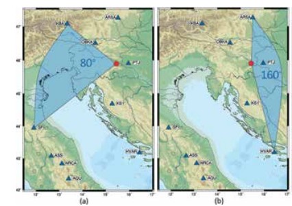
For reference see attached figure, where (a) shows primary azimuthal (b) secondary azimuthal gap
Is there someone who may familiar with concepts of azimuthal gaps (primary and secondary) in seismology. How user can determine these azimuthal gaps, which data is required for their calculation?
If user have earthquakes-stations co-ordinates, is it possible to determine their azimuthal gaps in GMT?
Kindly help me, so I can solve this issue. Thanks.