Gulf_Guinea_map_legend.txt (317 Bytes)
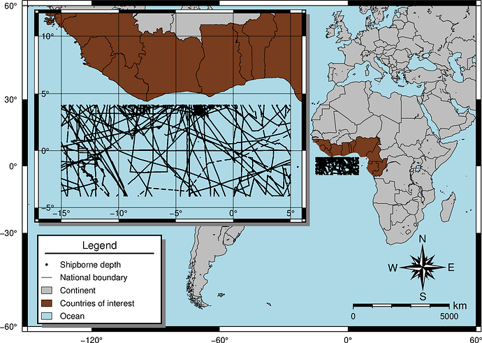
I am trying to recreate the attached map which I have unfortunately lost its script. My challenge now is I have forgotten how to get the graticules of the inset to show. I can’t attach the sounding data due to its huge size. Below is the script I have been able to reproduce so far:
gmt begin Gulf_Guinea_map png
gmt set FONT_ANNOT_PRIMARY 8p,Helvetica,black
gmt set FONT_ANNOT_SECONDARY 8p,Helvetica,black
gmt set FONT_LABEL 10p,Helvetica,black
gmt set FONT_TITLE 10p,Helvetica,black
gmt set MAP_TITLE_OFFSET 0.1c

gmt coast -JM6i -R-150/60/-60/60 -Ggray -Slightblue -Dc -Wthinnest ^
-EGH,NG,CI,TG,CM,BJ,CG,GA,GN,GW,LR,ST,SL,GQ+gdarkbrown -BSWne ^
-Bx60 -By30 -N1 -Lg25/-55+c0+w5000k+f+ar+lkm ^
-Tdg35/-43+w1.5c+f3+l
gmt plot Wholeregion_sounding.txt -Sc0.02c

	gmt inset begin -DjTL+w9c/7c+o0.35c/0.25c -F+gwhite+p1p+c0.1c+s
		gmt set MAP_ANNOT_OFFSET_PRIMARY -0.1c
		gmt coast -JM? -R-17/6/-6/12 -Ggray -Slightblue -Df -Wthin ^
		-EGH,NG,CI,TG,CM,BJ,CG,GA,GN,GW,LR,ST,SL,GQ+gdarkbrown -BSWne ^
		-Bx5 -By5 -N1 -Bg5
		gmt plot Wholeregion_sounding.txt -Sc0.02c
	gmt inset end

gmt legend -DjBL+w4.2c/3.0c+o0.35c/0.1c -F+p1p+gwhite+s -C0.3c/0.4c Gulf_Guinea_map_legend.txt
gmt end show

