Hi everyone , I am Mayur Rele , cyber security expert and cloud automation leader, has extensive experience in overseeing global technology, security, and cloud infrastructure in healthcare, e-commerce, and technology companies. Mayur graduated with an M.S. in Computer and Telecommunications Engineering from Stevens Institute of Technology and is an active IEEE researcher and contributor.
1 Like
Hello eveyrone,
My name is Redouane, a Seismologist, using gmt (mostly the 4.5… version) since 2013.
Hope we can learn from each other.
Have a nice day

2 Likes
Hello everyone, My name Dayat, I am a reseacher and curiosity to use GMT. Its nice to be here.
1 Like
Hello everyone,
I’m Yvonne. I started using GMT during my Bachelor thesis in 2017 and continued writing classic mode GMT Shell-scripts during my Master. Since 2021 I am a PhD student working on shear wave splitting and pleased to use PyGMT. It’s great to have all the Python functionality and the PyData ecosystem together with GMT  !
!
4 Likes
I am Jean Luc of University of Lubumbashi DRCongo. I am interested with the GMT flexure in the scope of PHD. My difficulty is to generate topo.txt file. How must be the header and number of columns in the file? Does the file be an XYZ?
1 Like
If you plan to do 2-D flexure in map view then it is grdflexure and it reads GMT grids, not ascii tables. if you have data in ascii form then you need to either convert it via xyz2grd (if already gridded but in ascii form) or you need to look at gridding in GMT in general (blockmean+surface, or near neighbor or greenspline).
How can i compile gmt grdflexure with topo.nc or topo.grd
$ gmt grdflexure topo.nc -Gflex.nc -E40k -D2700/3300/1035
I get this message:
$ grdflexure [ERROR]: Load grid topo.nc has NaNs, cannot be used with FFTs - file skipped
I have simplified that in the master repo but if you are running 6.4.0 then please change the NaNs to 0 via
gmt grdmath topo.nc 0 DENAN = topo_no_nans.nc
and use topo_no_nans.nc with grdflexure.
Hi,
The problem with these tools is that one need to have some deeper knowledge of what we are asking it to do. For example, when the error message says
[ERROR]: Load grid topo.nc has NaNs, cannot be used with FFTs
it is supposed that the user understands why is that so. I’m afraid the solution is not to ask “how can I compile it so it works”. No, the solution is to use grids that do not have NaNs.
(PW, I knew that we would get here. Doubt that wrapping the error is the best solution.)
Hi
Thanks for the reply, I am a beginner with GMT. I would like to know more about it
Thanks for the response, It works perfectly. The problem was to remove NaNs in my grid topo.nc
Hello Leonardo, hello GMT developers and community, my name is Miguel Vences, I am a biologist based at Braunschweig University of Technology in Germany (www.mvences.de). My group is contributing to develop user-friendly software tools for biological taxonomy (www.itaxotools.org), which also includes a geographical mapping component. We hope to use PyGMT for this purpose. I am not a programmer myself and probably will be asking some “silly” questions every now and then (starting with the first one today) - thanks in advance for your patience!
1 Like
Hi, I am a computer scientist in Chicago. I am currently using GMT to map data transfers with Globus (https://globus.org).
Hello everyone!
I am Mohammad Mohseni Aref, a PhD candidate at Potsdam University . I am interested in using GMT and PyGMT as my main tools to map my results. I am glad to join this community !
Hi there. I am a professor in planetary sciences and absolutely new to GMT.
Hi everyone, I’m PhD research student from Ocean university of China. Actually, I am new to use the pygmt. I have download everything and even laucnhed the jupyter notebook through conda in which i selected the pygmt from the kernel. but still not working if i try to import the pygmt. while in the conda shell if I try set the environment it shows no sufficient memory. thank you and nice meet you
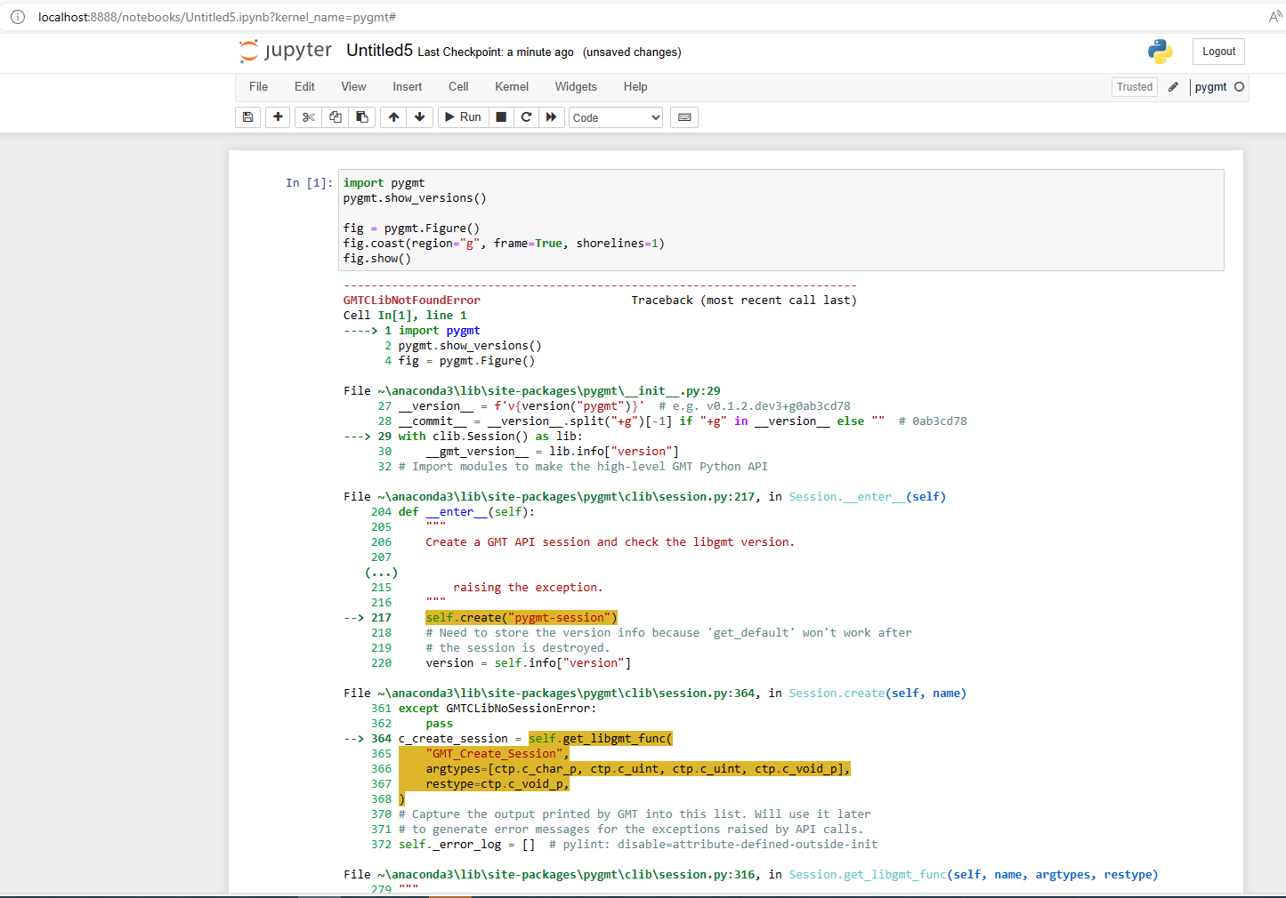
GMTCLibNotFoundError: Error loading GMT shared library at ‘gmt.dll’.
Could not find module ‘gmt.dll’ (or one of its dependencies). Try using the full path with constructor syntax.
Error loading GMT shared library at ‘gmt_w64.dll’.
Could not find module ‘gmt_w64.dll’ (or one of its dependencies). Try using the full path with constructor syntax.
Error loading GMT shared library at ‘gmt_w32.dll’.
Could not find module ‘gmt_w32.dll’ (or one of its dependencies). Try using the full path with constructor syntax.
Greetings. My name is Paul. I immigrated from South Africa to Hawaii and rekindled my interest in GIS and marine mapping. I am familiar with ArcGIS and QGIS. I want to learn GMT as a tool to analyse data for GIS.
1 Like
Hi all, Chris Olson here. I worked with gmt4 awhile back as I was just starting my career. I recently moved to Hawaii and started work as a developer for PacIOOS and am finding myself using GMT a lot more in this new role. I’m glad to see this forum exists and the community on it!
Hallo, I am Molly (Morfydd)
I am an historian working as an archivist but I am also one of the moderators at xPlanet. I am working on adding a companion application to incorporate various GIS tools to add JPL images to available maps. GDAL and GMT may be a part of this. I am investigating and may ask some non-expert questions.
Ciao
– Molly