Hello,
Some years ago, I did a perspective map with GMT 5 using grdview (attached file GMT5_Chicxulub_Bouguer…).
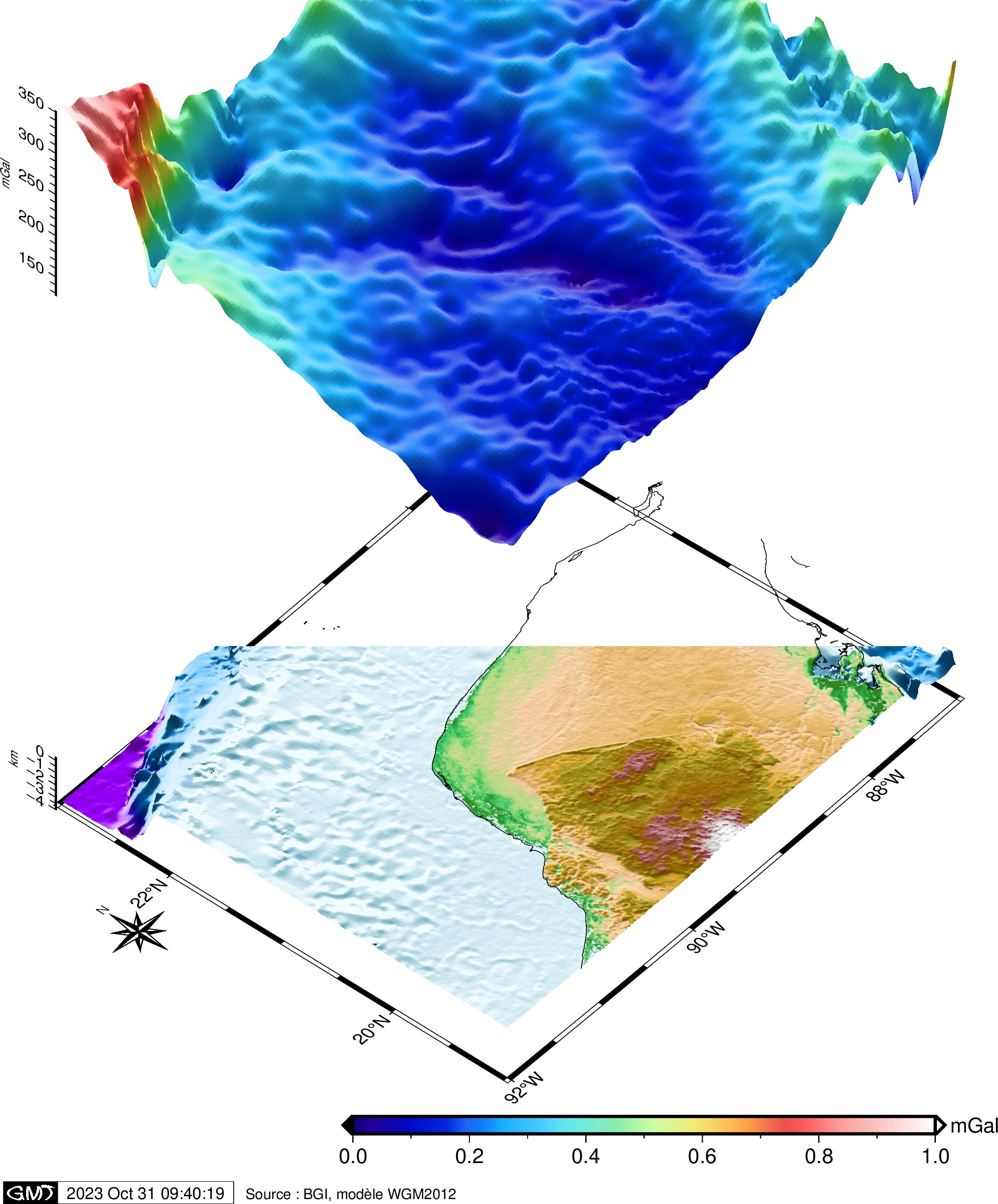
I’m trying to convert the code for GMT6.4.0 but the output images generated with grdview are curiously cutted (topographic map below as well as the gravity data above, see file GMT6_Chicxulub_Bouguer_… and output image).
Is that a specific grdview problem, or an error in my GMT6 code ?
The output images are joined below (GMT5 and GMT6-made) and the associated scripts are given in the zip archive.
Thanks a lot for help,
Cyril
Chicxulub_GMT5-GMT6-scripts.zip (4.0 KB)
Cannot test without a minimum work (i.e., failing) example. Your data files are not available to me but for gebco I can use @earth_gebco_15s since built in as remote dataset in GMT. Not so for your Bouguer grid. If you can post what I need (the Bouguer grid, anything else) we can at least see if we get the same problem.
Hello,
The topographic map is similarly cut when I use Etopo grid rather than gebco, or @earth_gebco_15s rather than my old gebco grid. Please find here my Bouguer dataset Bouguer_Chicxulub.txt (821.0 KB)
It seems the problem comes from grdview, as both topographic and Bouguer maps are cut along the same line.
Thanks again.
Hello. I’ve tried again to draw my map of the Bouguer anomaly of the Chicxulub crater with the new GMT6.5.0 but the topographic and the gravity map stay cropped like in my first message. The map frames are correctly drawn, but the data are not.
Hello. To be sure, I compile again my old GMT5 code using the last GMT5 version (5.4.5) and the current GMT6 (6.5.0) program, and the GMT5 is correctly drawn, with all the data on the oblique view, as expected, but the GMT6 grdcut module crops the top right corner of the data, both topographic and gravitational ones.
Yes, bugs are striking here. See issue #8415. Basically your options for now are: (1) use -Qs. (2) Use a different projection.
Hello Joaquim. Thanks, you’ve find the problem : using -Qs gives me the correct map. So, it is maybe not a real bug : I’ve left in the code the -Qc option that was available with GMT5 version of grdview but is no more proposed in GMT6. Replacing -Qc with -Qs gives the complete map.