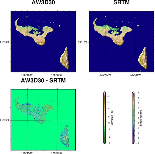
I was looking at DEMs and found the ALOS Global Digital Surface Model which is meant to be pretty good. So I decided to compare it against SRTM data which most of us are familiar with from the @earth_relief remote datasets which are supplied with GMT.
One needs to register to get the data, but they’re free, and supplied as GeoTIFFs, along with good documentation. I prepared some 1 arc second resolution data for Tonga, and compared them against the highest resolution SRTM data. The script is below:
#!/usr/bin/env bash

# Data files.
aw3d30_file="aw3d30.nc"             # Pixel registration
srtm_file="@srtm_relief_01s"        # Grid point registration

# Settings for Tonga Map Grid (2005)
gmt gmtset PROJ_ELLIPSOID=GRS-80

# Sample SRTM data onto same grid as AW3D30 for Tonga region.
gmt grdsample "${srtm_file}" -Gsrtm.nc -I1s \
   -R-175:24:0.5/-174:48:0.5/-21:30:0.5/-21:0:0.5

# Difference between AW3D30 and SRTM
gmt grdmath "${aw3d30_file}" srtm.nc SUB = diff.nc

gmt begin tongadem png
   gmt subplot begin 2x2 -Fs10c/10c
      gmt subplot set
      gmt makecpt -Cetopo1 -T1/300/1
      gmt grdimage aw3d30.nc -JT-177/0/9c \
         -R-175:23:0.5/-21:29:0.5/-174:51:0.5/-21:0:0.5+r -I \
         -BWSen+t"AW3D30" -Bpxf3ma15mg15m -Bpyf3ma15mg15m
      gmt subplot set
      gmt makecpt -Cetopo1 -T1/300/1
      gmt grdimage srtm.nc -JT-177/0/9c \
         -R-175:23:0.5/-21:29:0.5/-174:51:0.5/-21:0:0.5+r -I \
         -BWSen+t"SRTM" -Bpxf3ma15mg15m -Bpyf3ma15mg15m
      gmt subplot set
      gmt makecpt -Crainbow -T-10/10/0.1
      gmt grdimage diff.nc -JT-177/0/9c \
         -R-175:23:0.5/-21:29:0.5/-174:51:0.5/-21:0:0.5+r -I \
         -BWSen+t"AW3D30 - SRTM" -Bpxf3ma15mg15m -Bpyf3ma15mg15m
      gmt subplot set
      gmt makecpt -Cetopo1 -T1/300/1
      gmt colorbar -JX9c/9c -R0/9/0/9 -Dx2/4.5+w7+e+v+jML \
         -Bf3a2+l"Elevation (m)" -Q -I
      gmt makecpt -Crainbow -T-10/10/0.1
      gmt colorbar -Dx6/4.5+w7+e+v+jML -Bf1a2+l"Difference (m)" -I
   gmt subplot end
gmt end show
And here are the comparison plots:
I cannot say with certainty which dataset is best. But the AW3D30 data do seem to resolve a few features such as some little islands better than the SRTM. I know LIDAR data exist for these islands, but I’ve not been able to find any freely downloadable data.
