Good morning dear friends,
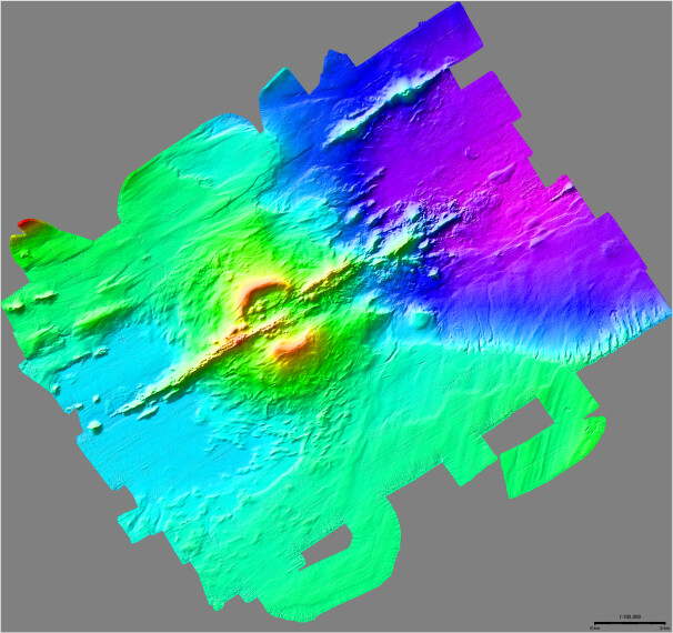
Sorry if this is a basic question, but I am trying to replicate the example 28 about mixing UTM and geographic datasets. I have managed to plot the DEM but I am not getting the mixed coordinates, could you please tell me where I am going wrong? My dem is in UTM 21S projected coordinates. Thank you in advance for your response. Attached image.
This is the script I used:
gmt begin the_axe_seamount
	# Set up a color rainbow
	gmt makecpt -Crainbow -T-1490/-290
	# Lay down the UTM topo grid using a 1:100,000 scale
	gmt grdimage the_axe_seamount.tif -I+d -Jx1:100000 --FONT_ANNOT_PRIMARY=9p
	# Overlay geographic data and coregister by using correct region and gmt projection with the same scale
	gmt coast -Rthe_axe_seamount.tif -Jutm/-21/1:100000 -Df+ -Slightblue -W0.5p -B5mg5m -BNE \
		--FONT_ANNOT_PRIMARY=12p --FORMAT_GEO_MAP=ddd:mmF
	echo 59:16:25W 62:37:54S Monte Submarino The Axe | gmt text -F+f12p,Helvetica-Bold+jCB
	gmt basemap --FONT_ANNOT_PRIMARY=9p -LjRB+c62:35S+f+w5k+l1:100,000+u+o0.5c --FONT_LABEL=10p
	# Annotate in km but append ,000m to annotations to get customized meter labels
	gmt basemap -Rthe_axe_seamount.tif+Uk -Jx1:100 -B5g5+u"@:8:000m@::" -BWSne --FONT_ANNOT_PRIMARY=10p \
		--MAP_GRID_CROSS_SIZE_PRIMARY=0.25c --FONT_LABEL=10p
gmt end show