Hello Seniors GMT users and Professors here, I am John, new to GMT but have some basic use of it, I want to know how to convert my geographic grid to the format that can work with Wavelet transform software to compute the effective elastic thickness of the lithosphere.
2. How do I convert bathymetry grid data to equivalent topography, using GMT to remove the effect of the water from my bathymetry grid data?
Many thanks
See the gravfft module. Note that you do not need to convert your grid to cartesians in order to use this program, but it doesn’t do any wavelets transforms.
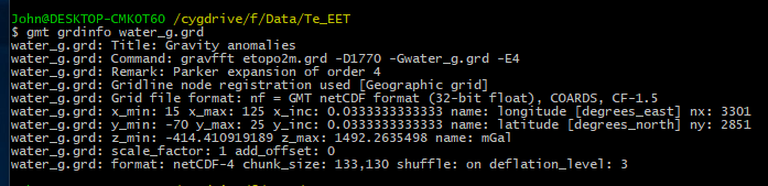
many thanks, Professor, I have used this module before but the z unit was changed to mgal. I have been using GMT since Last year December , I tried this many time but the Z unit changed from meters to mgal which is the unit of gravity.
But how can I convert my grid data to wavelet transform data format?
GMT modules that I used for coherence data format are not compatible for wavelet transform format
I’m sorry but I don’t understand this sentence. What is a wavelet data format?
Anyway, as I mentioned earlier, we don’t have any kind of wavelet transforms in GMT.
Well, if you calculated the gravity effect of a peace of terrain, it’s normal to get mGal. Again, I don’t understand what is the question here. Please try to be more specific.
Wavelet transform is a code suit to calculate the effective thickness of the lithosphere, the software requires I convert my data to the data compatible with wavelet transform for it to work just as I did for coherence method, so I need to convert my Bouguer and topography to the input format to work with the software.
I mean before I asked this question on how to calculate equivalent topography, I had already used gravfft , where I subtracted the water density from the Bathymetry density then use it with the Bathymetry data on gravfft to get the equivalent topography but the z unit returns as Mgal, from this picture, so can we say the result from this operation on gravftt is the equivalent topography?
Many thanks Professor.
But since we have no idea what is the format required by that (unknown) code, there is nothing we can do to help. Right?
What you did here was what is explained in the manual right above the example that you used.
To compute the effect of the water layer above the bat.grd bathymetry using
And next paragraph says:
Now subtract it from your free-air anomaly faa.grd and you will get the Bouguer anomaly.
So what you got was the full Bouger gravity anomaly, whose unites are mGals.
Another thing to complicate your life is that your grid extents is very large [-70 to 25] N. A region of this size is too big to use FFT methods when grid is in geographical coordinates. FFT assumes that x_inc/y_inc are constant throughout the domain, which is clearly not the case for x_inc from -70 to 0 degrees latitude.
of course, nothing can be done, I will have to see other researchers using the wavelet transform to help me on that, many thanks Professor.
I have my Bouguer gravity data. I only need to calculate and remove the effect of water anomalies from my bathymetry data, and I used the gravfft module as you said earlier.
But if you remove the effect of the water layer from the Bouger anomaly you’ll end up with the free air anomaly, which the the data that you started with (over the oceans what we measure is the FAA). If you want to do that scaling, just use grdmath.
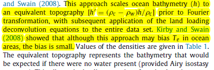
Professor, many thanks, what I want to do is scale i.e. scaling the Bathymetry(h) to an equivalent topography, which actually means removing the effect of water layer from the Bathymetry data.
Because equivalent topography represents the bathymetry that would be expected if there were no water present ( provided Airy isostasy operates).
However, I have once upon a time used grdmath but sir, how can I used grdmath when I don’t have the water grid data that I will subtract from the Bathymetry data.
Can I get more explanation on grdmath on this from you?
Hi @John, please use the Q&A category to ask questions. I have moved this topic there.
It also really helps us better answer your questions if you follow a few simple guidelines: https://stackoverflow.com/help/how-to-ask
ok sir, many thanks. I will do that
@John I confess that I never used the equivalent layer method but if all you want is to scale by (Rho_c - Rho_w)/Rho_c then calculate that scale factor and apply it to bathymetry. Something like
gmt grdmath bathym.grd scale MUL = scaled_bathym.grd
already this it this afternoon in my office, correct sir,
I used (gmt grdmath bathm.grd 0.6321 MUL = equivalent topography)
where 0.6321 = (2800-1030)/2800 = 1770/2800 = 0.6321
I just wanted to see your view, I try first to use the GMT functions first before asking a question to clear doubt