I am using pscoast to create an image of the world when I user picks certain points. When I pick a point on the map the point is chicago area. When the map gets created the image is Argentina and Antarctica area. What am I doing incorrectly.
ps_image=‘midwest.ps’
png_image=‘/dev/shm/midwest.png’
dest=‘/data1/images/midwest.png’
gmt set PROJ_LENGTH_UNIT i && gmt pscoast -P -Rg -JG41.86/-87.6/2 -W.1,0/100/0 -G0/100/0 -S177/224/230 -Dc -A5000 -K -Xc > /dev/shm/$ps_image
gmt pssolar -R -J -Td+d2021-11-10T18:45:01 -Gblack@50 -K -O >> /dev/shm/$ps_image
gmt pssolar -R -J -Tc+d2021-11-10T18:45:01 -Gblack@60 -K -O >> /dev/shm/$ps_image
gmt pssolar -R -J -Tn+d2021-11-10T18:45:01 -Gblack@70 -K -O >> /dev/shm/$ps_image
gmt pssolar -R -J -Ta+d2021-11-10T18:45:01 -Gblack@80 -O >> /dev/shm/$ps_image
gmt psconvert -A+s4.33c -TgG /dev/shm/$ps_image
convert $png_image -resize 50% -sharpen 0x.9 $png_image
mv $png_image $dest
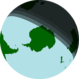
You’re telling the script to center the global projection at -87º latitude… so Antartica ![]()
That was a huge misstep thank you.