Hello,
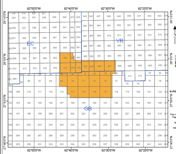
I am trying to generate a base map that, visualize the block boundaries on it, and map the block names to their respective block (please see attached image). I have 2 dataset to achieve that, blocks.shp and blocks.dbf.
Here is a snippet of my code:
import pygmt

fig = pygmt.Figure()
xmin = -92
xmax = -91.3
ymin = 28
ymax = 28.5

region = [xmin, xmax, ymin, ymax]
projection = f"M{(xmin+xmax)/2}/{(ymin+ymax)/2}/10c"

fig.basemap(region=region, projection=projection, frame=True)

# protraction boundaries
fig.plot(
    data='/content/protrac.shp',
    region=region,
    projection=projection,
    pen='black'
)

# block boundaries
fig.plot(
    data='/content/blocks.shp',  # Replace 'block_shapefile.shp' with the actual filename and path
    region=region,
    projection=projection,
)

#Proposed code to map the block names but I am sure this is wrong
fig.plot(
    data='/content/blocks.dbf',  # Replace 'block_shapefile.shp' with the actual filename and path
    region=region,
    projection=projection,
)


fig.plot(
    x=-91.4616,
    y=28.3668,
    style='a0.1i',
    color='red',
    pen='black',
    label='BH_Well',
)

fig.legend(position="JTR+jTR+o0.2c/0.2c", box=True)

with pygmt.config(FONT_TITLE=8):
    fig.basemap(rose="jTL+w1.3c+lO,E,S,N+o-0.1c/3c")

fig.savefig("gulf_of_mexico_bathymetry.png")
fig.show()
Thank you
