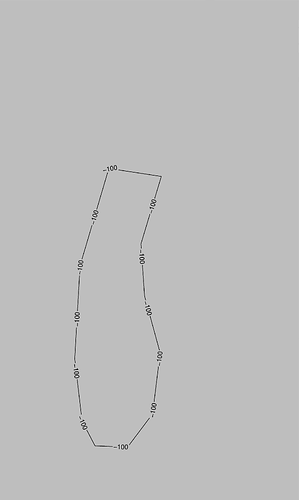
This code:
gmt psxy Michigan_Elev_Contour.xy.txt %ALL% -W0.50p,black -Sqd1.0i:+d+Lh -O -K >> %ps%
stopped working - no labels and no lines. But this one:
gmt psxy Michigan_co_100_m_Elev_Contour.xy.txt %ALL% -W0.50p,black -O -K >> %ps%
draws lines
We cannot work on hypothetical examples. Please provide a MWE (minimum working example) showing the issue.
set ps="Michigan.ps"
gmt gmtset FORMAT_GEO_MAP ddd:mm:ss MAP_GRID_CROSS_SIZE_PRIMARY 0 MAP_FRAME_TYPE graph
pscoast -R-88.50/41.45/-84.56/46.23r -Jt-86.3855/1:2175000 -P -Df -Ggray -Sgray -K > %ps%
gmt psxy Michigan_Elev_Contour.xy.txt -R-88.50/41.45/-84.56/46.23r -Jt-86.3855/1:2175000 -P -W0.50p,black -Sqd1.0i:+d+Lh -O >> %ps%
:: gmt psxy Michigan_Elev_Contour.xy.txt -R-88.50/41.45/-84.56/46.23r -Jt-86.3855/1:2175000 -P -W0.50p,black -O >> %ps%
Michigan_Elev_Contour.xy.txt:
> -L"-100" -Sqd1.0i
-86.45235040920656 44.56074532391791
-87.15496366731526 44.63460538965384
-87.52203359612746 43.70375243465723
-87.57565650687522 42.81267315180862
-87.46872284091027 42.21696862267483
-87.29959207789203 41.98325754479477
-86.88164979096022 41.9742639278875
-86.56233691428744 42.29261909586023
-86.46591956240054 42.8760163962448
-86.67090781901327 43.41777121767043
-86.7207951116628 43.91664988596499
-86.45235040920656 44.56074532391791
… Yes. This example works. I made mistake in the file name (“Michigan_co_100_m_Elev_Contour.xy.txt” instead of “Michigan_Elev_Contour.xy.txt”). Sorry …
But the real xy file consists of many lines. If you have time, try this:
Michigan_Elev_Contour.xy.txt:
> -L"-100" -Sqd1.0i
-86.45235040920656 44.56074532391791
-87.15496366731526 44.63460538965384
-87.52203359612746 43.70375243465723
-87.57565650687522 42.81267315180862
-87.46872284091027 42.21696862267483
-87.29959207789203 41.98325754479477
-86.88164979096022 41.9742639278875
-86.56233691428744 42.29261909586023
-86.46591956240054 42.8760163962448
-86.67090781901327 43.41777121767043
-86.7207951116628 43.91664988596499
-86.45235040920656 44.56074532391791
(the some line repeat twice, but it doesn’t matter). It won’t work.
Sorry, I don’t understand. The name doesn’t matter. In this second post the file contents are the same. Why the result would be different?
Note that you can attach data files here. Please do so with the file that fails (+ plus the command to confirm).
The Michigan_Elev_Contour.xy.txt: file in second post contains coordinates of points of two lines:
> -L"-100" -Sqd1.0i
…
> -L"-100" -Sqd1.0i
…
And this file doesn’t work.
Psxy … -Sq … stopped working in GMT 6.0 for xy files containing more than one line. Run this script and you will see.
Just so I understand your intent here: Normally, any -S in a segment header will override what is given on the command line. So your command means draw those lines without using the labels since there is no +Lh in the file? If you do want the labels, it would be the opposite of what GMT expects I think. So just want to clarify what you are trying to do.
So this is such misunderstanding between bat and xy files ? When “-Sqd1.0i” is replaced by “-Sqd1.0i:+d+Lh” in the Michigan_Elev_Contour.xy.txt file:
> -L"-100" -Sqd1.0i:+d+Lh
…
> -L"-100" -Sqd1.0i:+d+Lh
…
it works really. But previous GMT versions were working with “-Sqd1.0i” alone in headers. And it fails only when xy file contains coordinates of more than one line, in case of single line works with “-Sqd1.0i”.
