Hello,
I am trying to plot Arc DEM using GMT 6.0 installed using conda on Mac OS.
I downloaded 1 kilometer ArcticDEM Mosaic arcticdem_mosaic_1km_v3.0.tif file DEM. According to the web site Mosaicked DEMs are provided in 32-bit GeoTIFF format.
-
- This is file info:
gmt grdinfo arcticdem_mosaic_1km_v3.0.tif
arcticdem_mosaic_1km_v3.0.tif: Title: Grid imported via GDAL
arcticdem_mosaic_1km_v3.0.tif: Command:
arcticdem_mosaic_1km_v3.0.tif: Remark:
arcticdem_mosaic_1km_v3.0.tif: Pixel node registration used [Cartesian grid]
arcticdem_mosaic_1km_v3.0.tif: Grid file format: gd = Import/export through GDAL
arcticdem_mosaic_1km_v3.0.tif: x_min: -4000000 x_max: 3400000 x_inc: 1000 name: n_columns: 7400
arcticdem_mosaic_1km_v3.0.tif: y_min: -3400000 y_max: 4100000 y_inc: 1000 name: n_rows: 7500
arcticdem_mosaic_1km_v3.0.tif: z_min: -718.904541016 z_max: 5912.12158203 name: z
arcticdem_mosaic_1km_v3.0.tif: scale_factor: 1 add_offset: 0
+proj=stere +lat_0=90 +lat_ts=70 +lon_0=-45 +x_0=0 +y_0=0 +datum=WGS84 +units=m +no_defs
- I tried to convert it to GMT native netcdf format
gmt grdconvert arcticdem_mosaic_1km_v3.0.tif -Garcticdem_mosaic_1km_v3.0.nc -V
- This is new Netcdf file info
gmt grdinfo arcticdem_mosaic_1km_v3.0.nc
arcticdem_mosaic_1km_v3.0.nc: Title: Produced by grdconvert
arcticdem_mosaic_1km_v3.0.nc: Command: grdconvert arcticdem_mosaic_1km_v3.0.tif -Garcticdem_mosaic_1km_v3.0.nc -V
arcticdem_mosaic_1km_v3.0.nc: Remark:
arcticdem_mosaic_1km_v3.0.nc: Pixel node registration used [Cartesian grid]
arcticdem_mosaic_1km_v3.0.nc: Grid file format: nf = GMT netCDF format (32-bit float), CF-1.7
arcticdem_mosaic_1km_v3.0.nc: x_min: -4000000 x_max: 3400000 x_inc: 1000 name: n_columns: 7400
arcticdem_mosaic_1km_v3.0.nc: y_min: -3400000 y_max: 4100000 y_inc: 1000 name: n_rows: 7500
arcticdem_mosaic_1km_v3.0.nc: z_min: -718.904541016 z_max: 5912.12158203 name: z
arcticdem_mosaic_1km_v3.0.nc: scale_factor: 1 add_offset: 0
arcticdem_mosaic_1km_v3.0.nc: format: netCDF-4 chunk_size: 130,130 shuffle: on deflation_level: 3
PROJCS[“unknown”,
GEOGCS[“unknown”,
DATUM[“WGS_1984”,
SPHEROID[“WGS 84”,6378137,298.257223563,
AUTHORITY[“EPSG”,“7030”]],
AUTHORITY[“EPSG”,“6326”]],
PRIMEM[“Greenwich”,0,
AUTHORITY[“EPSG”,“8901”]],
UNIT[“degree”,0.0174532925199433,
AUTHORITY[“EPSG”,“9122”]]],
PROJECTION[“Polar_Stereographic”],
PARAMETER[“latitude_of_origin”,70],
PARAMETER[“central_meridian”,-45],
PARAMETER[“false_easting”,0],
PARAMETER[“false_northing”,0],
UNIT[“metre”,1,
AUTHORITY[“EPSG”,“9001”]],
AXIS[“Easting”,SOUTH],
AXIS[“Northing”,SOUTH]]
- I tried to make some changes:
gmt grdedit arcticdem_mosaic_1km_v3.0.nc -R-180/180/60/90 -D+t"Arctic DEM Mosaic 500 m" -T -fg
and made a figure
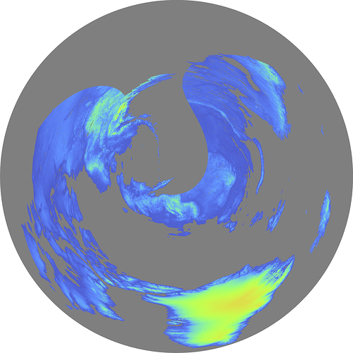
gmt grdimage -Js0/90/12c/60 -R-180/180/60/90 arcticdem_mosaic_1km_v3.0.nc -pdf arcticdem1km
The grid is distorted.
Any help is greatly appreciated.
Thank you,
Andrei

